
Panton Hill topographic map
Interactive map
Click on the map to display elevation.
About this map
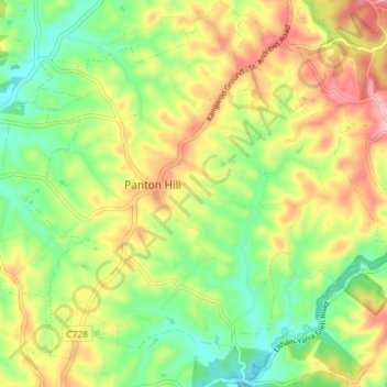
Name: Panton Hill topographic map, elevation, terrain.
Location: Panton Hill, Shire of Nillumbik, Victoria, 3759, Australia (-37.67124 145.21507 -37.61422 145.28610)
Average elevation: 499 ft
Minimum elevation: 253 ft
Maximum elevation: 817 ft
Other topographic maps
Click on a map to view its topography, its elevation and its terrain.
Panton Hill
Australia > Victoria > Panton Hill
Panton Hill, Shire of Nillumbik, Victoria, 3759, Australia
Average elevation: 492 ft
Cottles Bridge
Australia > Victoria > Panton Hill
Cottles Bridge, Panton Hill, Shire of Nillumbik, Victoria, Australia
Average elevation: 469 ft