Geolocate

Thruxton topographic map

Click on the map to display elevation.

About this map

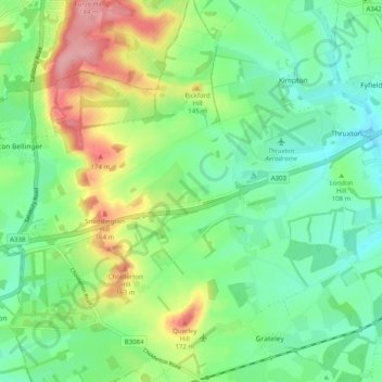
Name: Thruxton topographic map, elevation, terrain.

Location: Thruxton, Test Valley, Hampshire, England, United Kingdom (51.18481 -1.66946 51.21679 -1.56947)

Average elevation: 364 ft

Minimum elevation: 233 ft

Maximum elevation: 620 ft

Other topographic maps

Click on a map to view its topography, its elevation and its terrain.

Islands

United Kingdom > England > Hampshire > Test Valley > West Tytherley

Average elevation: 213 ft

Gear up for your next adventure:

🧦Merino Wool Socks - Moisture-wicking, blister-preventing socks for long treks
🧦Hiking Socks - Comfortable socks to prevent blisters on long hikes
🧴Hand Sanitizer - Keep hands clean while hiking
🖼️Topo Map Wall Art - Decorative topographic prints of famous peaks and regions
🏕️Tent Footprint - Protect your tent base from wear

As an Amazon Associate, this site earns from qualifying purchases at no extra cost to you.