Geolocate

Kihei topographic map

Click on the map to display elevation.

About this map

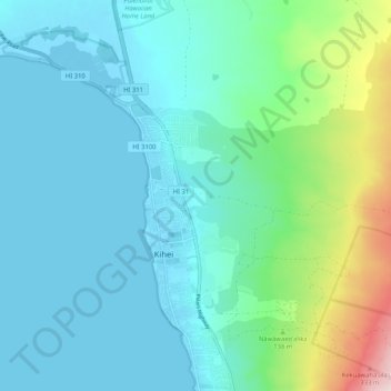
Name: Kihei topographic map, elevation, terrain.

Location: Kihei, Maui County, Hawaii, United States (20.71347 -156.49069 20.81071 -156.40079)

Average elevation: 243 ft

Minimum elevation: -16 ft

Maximum elevation: 1,329 ft

Maui County trails, hiking, mountain biking, running and outdoor activities

Gear up for your next adventure:

🪑Portable Camp Table - Compact table for campsite meals
🛌Ultralight Sleeping Bags - Compact down bags for cold nights in the wilderness
🔦LED Headlamp - Bright and durable LED headlamp for night navigation
🎒Outdoor Daypacks - Lightweight backpacks designed for carrying maps and essential gear
💧Water Purification System - Clean water on the trail with reliable purifiers

As an Amazon Associate, this site earns from qualifying purchases at no extra cost to you.