
Halabja topographic map
Interactive map
Click on the map to display elevation.
About this map
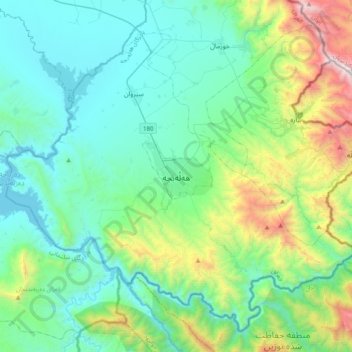
Name: Halabja topographic map, elevation, terrain.
Average elevation: 2,956 ft
Minimum elevation: 1,467 ft
Maximum elevation: 8,638 ft
Other topographic maps
Click on a map to view its topography, its elevation and its terrain.
Ghulami Lower Old
Iraq > Halabja Governorate > Halabja District
Ghulami Lower Old, Sirwan Sub-District, Halabja District, Halabja Governorate, Iraqi Kurdistan Region, 46018, Iraq
Average elevation: 1,742 ft