
Jaigaon topographic map
Interactive map
Click on the map to display elevation.
About this map
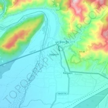
Name: Jaigaon topographic map, elevation, terrain.
Location: Jaigaon, Kalchini, Alipurduar, West Bengal, 735182, India (26.81486 89.33673 26.89486 89.41673)
Average elevation: 1,037 ft
Minimum elevation: 505 ft
Maximum elevation: 3,156 ft
Other topographic maps
Click on a map to view its topography, its elevation and its terrain.
Hamiltonganj
India > West Bengal > Kalchini > Hamiltonganj
Hamiltonganj, Kalchini, Alipurduar, West Bengal, 735214, India
Average elevation: 354 ft