
Make a donation
Gear up for your next adventure:
As an Amazon Associate, this site earns from qualifying purchases at no extra cost to you.
Miaoli County topographic map
Click on the map to display elevation.
Make a donation
Gear up for your next adventure:
As an Amazon Associate, this site earns from qualifying purchases at no extra cost to you.
About this map
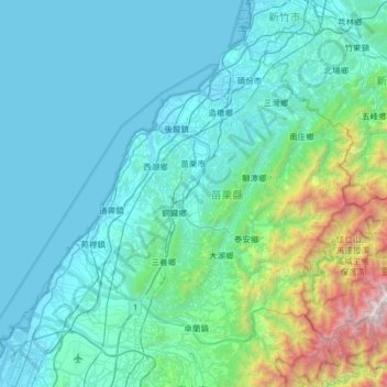
Name: Miaoli County topographic map, elevation, terrain.
Location: Miaoli County, Taiwan Province, Taiwan (24.28852 120.62186 24.74107 121.26264)
Average elevation: 1,407 ft
Minimum elevation: -3 ft
Maximum elevation: 11,447 ft
Make a donation
Gear up for your next adventure:
As an Amazon Associate, this site earns from qualifying purchases at no extra cost to you.
Other topographic maps
Click on a map to view its topography, its elevation and its terrain.
Songbailun
Taiwan > Taiwan Province > Nantou County > Yuchi Township > Songbailun
Average elevation: 2,533 ft
Make a donation
Gear up for your next adventure:
As an Amazon Associate, this site earns from qualifying purchases at no extra cost to you.