
Pretin topographic map
Interactive map
Click on the map to display elevation.
About this map
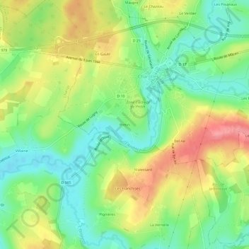
Name: Pretin topographic map, elevation, terrain.
Average elevation: 1,007 ft
Minimum elevation: 883 ft
Maximum elevation: 1,171 ft
Other topographic maps
Click on a map to view its topography, its elevation and its terrain.
Château de Charolles
France > Bourgogne-Franche-Comté > Saône-et-Loire > Charolles
Château de Charolles, Rue Gambetta, Cité Bel Air, Charolles, Saône-et-Loire, Bourgogne-Franche-Comté, France métropolitaine, 71120, France
Average elevation: 1,004 ft
Brèches
France > Bourgogne-Franche-Comté > Saône-et-Loire > Charolles
Brèches, Charolles, Saône-et-Loire, Bourgogne-Franche-Comté, France métropolitaine, 71120, France
Average elevation: 1,070 ft
Le Verdier
France > Bourgogne-Franche-Comté > Saône-et-Loire > Charolles
Le Verdier, Charolles, Saône-et-Loire, Bourgogne-Franche-Comté, France métropolitaine, 71120, France
Average elevation: 1,017 ft