
Make a donation
Gear up for your next adventure:
As an Amazon Associate, this site earns from qualifying purchases at no extra cost to you.
Tikal topographic map
Click on the map to display elevation.
Make a donation
Gear up for your next adventure:
As an Amazon Associate, this site earns from qualifying purchases at no extra cost to you.
Tikal
The city has been completely mapped and covered an area greater than 16 square kilometers (6.2 sq mi) that included about 3,000 structures. The topography of the site consists of a series of parallel limestone ridges rising above swampy lowlands. The major architecture of the site is clustered upon areas of higher ground and linked by raised causeways spanning the swamps. The area around Tikal has been declared as the Tikal National Park and the preserved area covers 570 square kilometers (220 sq mi). It was created on 26 May 1955 under the auspices of the Instituto de Antropología e Historia and was the first protected area in Guatemala.
Make a donation
Gear up for your next adventure:
As an Amazon Associate, this site earns from qualifying purchases at no extra cost to you.
About this map
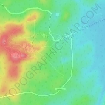
Name: Tikal topographic map, elevation, terrain.
Location: Tikal, Mahler Causeway, Flores, Petén, Guatemala (17.20940 -89.63277 17.23224 -89.61175)
Average elevation: 856 ft
Minimum elevation: 735 ft
Maximum elevation: 1,043 ft
Make a donation
Gear up for your next adventure:
As an Amazon Associate, this site earns from qualifying purchases at no extra cost to you.