
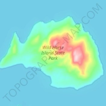
Wild Horse Island topographic map
Interactive map
Click on the map to display elevation.
About this map
Name: Wild Horse Island topographic map, elevation, terrain.
Location: Wild Horse Island, Lake County, Montana, United States (47.82879 -114.24866 47.85777 -114.18785)
Average elevation: 3,005 ft
Minimum elevation: 2,884 ft
Maximum elevation: 3,737 ft
The island was formed by the Cordilleran Glacier, giving the island a varying topography. Its shores are 2,900 feet (880 m) above sea level. The glacier caused the six summits in the center of the island, ranging in heights between 3,277 and 3,745 feet (999 and 1,141 m), to be formed into rôche moutonnée, with rugged northern faces and rugged southern cliffs. Meadows sprawl the western and southern shores, while grasslands cover the southeast. The northern side of the island has forests of Ponderosa pine and Douglas fir trees. The highest point is at 3,749 feet (1,143 m), which is 853 feet (260 m) above the island's shores.
Other topographic maps
Click on a map to view its topography, its elevation and its terrain.
Flathead Lake
United States > Montana > Lake County
Flathead Lake, Lake County, Montana, United States
Average elevation: 3,832 ft
Picture Lake
United States > Montana > Lake County
Picture Lake, Lake County, Montana, United States
Average elevation: 7,283 ft
Kicking Horse
United States > Montana > Lake County
Kicking Horse, Lake County, Montana, United States
Average elevation: 3,077 ft