
Thank you for supporting this site ❤️
Make a donation
Make a donation
Gear up for your next adventure:
As an Amazon Associate, this site earns from qualifying purchases at no extra cost to you.
Tourais topographic map
Click on the map to display elevation.
Thank you for supporting this site ❤️
Make a donation
Make a donation
Gear up for your next adventure:
As an Amazon Associate, this site earns from qualifying purchases at no extra cost to you.
About this map
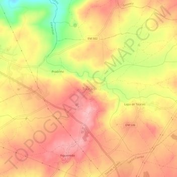
Name: Tourais topographic map, elevation, terrain.
Location: Tourais, Seia, Guarda, 6270-584, Portugal (40.45136 -7.77078 40.49136 -7.73078)
Average elevation: 1,404 ft
Minimum elevation: 1,099 ft
Maximum elevation: 1,568 ft
Thank you for supporting this site ❤️
Make a donation
Make a donation
Gear up for your next adventure:
As an Amazon Associate, this site earns from qualifying purchases at no extra cost to you.