Geolocate

Aurora topographic map

Click on the map to display elevation.

About this map

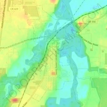
Name: Aurora topographic map, elevation, terrain.

Location: Aurora, Marion County, Oregon, United States (45.21719 -122.76550 45.24142 -122.74775)

Average elevation: 141 ft

Minimum elevation: 75 ft

Maximum elevation: 236 ft

Marion County trails, hiking, mountain biking, running and outdoor activities

Other topographic maps

Click on a map to view its topography, its elevation and its terrain.

Drake Crossing

United States > Oregon > Marion County

Average elevation: 1,552 ft

Macleay

United States > Oregon > Marion County

Average elevation: 443 ft

Sam Brown Creek

United States > Oregon > Marion County

Average elevation: 161 ft

Gear up for your next adventure:

🪶Wildlife Field Guides - Learn animal tracking and species ID
🔪Outdoor Multitools - Essential survival tools for gear repair and field use
👟Men's Trail Runners - Lightweight footwear for fast-paced exploration and light hiking
🔥Fast-Boil Camping Stoves - Efficient cooking systems for quick trail meals
🎒Day Hiking Backpack - Lightweight backpack perfect for day trips and outdoor adventures

As an Amazon Associate, this site earns from qualifying purchases at no extra cost to you.