
Manteigas Santa Maria topographic map
Interactive map
Click on the map to display elevation.
About this map
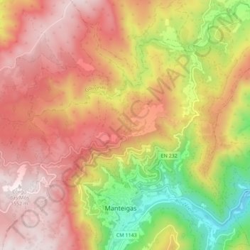
Name: Manteigas Santa Maria topographic map, elevation, terrain.
Average elevation: 3,743 ft
Minimum elevation: 2,001 ft
Maximum elevation: 5,052 ft
Other topographic maps
Click on a map to view its topography, its elevation and its terrain.
Parque Natural da Serra da Estrela
Portugal > Centro > Manteigas Santa Maria
Parque Natural da Serra da Estrela, EN 232, Granja, C. Maria Viegas, Manteigas Santa Maria, Manteigas, Guarda, Beira Interior Norte, Centro, 6260-118, Portugal
Average elevation: 2,428 ft