
Autonomous Region of Príncipe topographic map
Interactive map
Click on the map to display elevation.
About this map
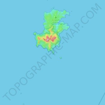
Name: Autonomous Region of Príncipe topographic map, elevation, terrain.
Location: Autonomous Region of Príncipe, São Tomé and Príncipe (1.33982 7.28160 1.72593 7.46997)
Average elevation: 46 ft
Minimum elevation: 0 ft
Maximum elevation: 3,005 ft
Other topographic maps
Click on a map to view its topography, its elevation and its terrain.
Trindade
São Tomé and Príncipe > Mé-Zóchi
Trindade, Mé-Zóchi, São Tomé and Príncipe
Average elevation: 1,785 ft
Penísula
São Tomé and Príncipe > Cantagalo > Agua Ize
Penísula, Agua Ize, Cantagalo, São Tomé and Príncipe
Average elevation: 89 ft
Formosa
São Tomé and Príncipe > São Tomé Province > Mé-Zóchi > Formosa
Formosa, Mé-Zóchi, São Tomé Province, São Tomé and Príncipe
Average elevation: 1,785 ft
Agua Grande
São Tomé and Príncipe > São Tomé Province > São Tomé
Agua Grande, São Tomé, Água Grande, São Tomé Province, 20000, São Tomé and Príncipe
Average elevation: 59 ft
Lembá
São Tomé and Príncipe > São Tomé Province
Lembá, São Tomé Province, São Tomé and Príncipe
Average elevation: 925 ft
Santa Fe
São Tomé and Príncipe > São Tomé Province > Santa Fe
Santa Fe, Mé-Zóchi, São Tomé Province, São Tomé and Príncipe
Average elevation: 1,129 ft