
Opole County topographic map
Interactive map
Click on the map to display elevation.
About this map
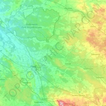
Name: Opole County topographic map, elevation, terrain.
Location: Opole County, Opole Voivodeship, Poland (50.50160 17.46624 50.96807 18.35442)
Average elevation: 630 ft
Minimum elevation: 446 ft
Maximum elevation: 1,306 ft
Other topographic maps
Click on a map to view its topography, its elevation and its terrain.
Olesno
Poland > Opole Voivodeship > Olesno County
Olesno, gmina Olesno, Olesno County, Opole Voivodeship, 46-300, Poland
Average elevation: 807 ft
Narok
Poland > Opole Voivodeship > Opole County > Narok
Narok, gmina Dąbrowa, Opole County, Opole Voivodeship, Poland
Average elevation: 489 ft
Nysa
Poland > Opole Voivodeship > Nysa
Nysa, gmina Nysa, Nysa County, Opole Voivodeship, Poland
Average elevation: 663 ft
Przywory
Poland > Opole Voivodeship > Przywory
Przywory, gmina Tarnów Opolski, Opole County, Opole Voivodeship, Poland
Average elevation: 525 ft
Niemodlin
Poland > Opole Voivodeship > Niemodlin > Niemodlin
Niemodlin, gmina Niemodlin, Opole County, Opole Voivodeship, 49-100, Poland
Average elevation: 558 ft