
Thank you for supporting this site ❤️
Make a donation
Make a donation
Gear up for your next adventure:
As an Amazon Associate, this site earns from qualifying purchases at no extra cost to you.
Nysa topographic map
Click on the map to display elevation.
Thank you for supporting this site ❤️
Make a donation
Make a donation
Gear up for your next adventure:
As an Amazon Associate, this site earns from qualifying purchases at no extra cost to you.
About this map
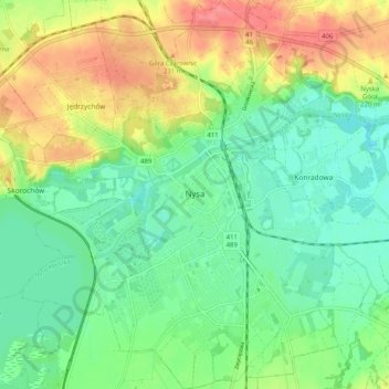
Name: Nysa topographic map, elevation, terrain.
Location: Nysa, gmina Nysa, Nysa County, Opole Voivodeship, Poland (50.44124 17.28730 50.50592 17.38663)
Average elevation: 663 ft
Minimum elevation: 574 ft
Maximum elevation: 804 ft
Thank you for supporting this site ❤️
Make a donation
Make a donation
Gear up for your next adventure:
As an Amazon Associate, this site earns from qualifying purchases at no extra cost to you.