
Thank you for supporting this site ❤️
Make a donation
Make a donation
Gear up for your next adventure:
As an Amazon Associate, this site earns from qualifying purchases at no extra cost to you.
Chambralles topographic map
Click on the map to display elevation.
Thank you for supporting this site ❤️
Make a donation
Make a donation
Gear up for your next adventure:
As an Amazon Associate, this site earns from qualifying purchases at no extra cost to you.
About this map
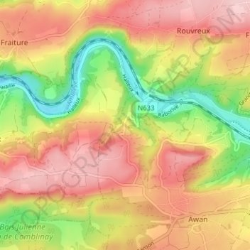
Name: Chambralles topographic map, elevation, terrain.
Location: Chambralles, Aywaille, Liège, Wallonia, 4920, Belgium (50.45536 5.61291 50.49536 5.65291)
Average elevation: 705 ft
Minimum elevation: 325 ft
Maximum elevation: 1,001 ft
Thank you for supporting this site ❤️
Make a donation
Make a donation
Gear up for your next adventure:
As an Amazon Associate, this site earns from qualifying purchases at no extra cost to you.