
Stayner topographic map
Interactive map
Click on the map to display elevation.
About this map
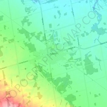
Name: Stayner topographic map, elevation, terrain.
Average elevation: 728 ft
Minimum elevation: 610 ft
Maximum elevation: 1,060 ft
Other topographic maps
Click on a map to view its topography, its elevation and its terrain.
New Lowell
Canada > Ontario > Simcoe County > Clearview
New Lowell, Clearview, Simcoe County, Central Ontario, Ontario, L0M 1N0, Canada
Average elevation: 689 ft
Creemore
Canada > Ontario > Simcoe County > Clearview
Creemore, Clearview, Simcoe County, Central Ontario, Ontario, L0M 1G0, Canada
Average elevation: 1,004 ft
Avening
Canada > Ontario > Simcoe County > Clearview
Avening, Clearview, Simcoe County, Central Ontario, Ontario, L0M 1G0, Canada
Average elevation: 846 ft