
Thank you for supporting this site ❤️
Make a donation
Make a donation
Gear up for your next adventure:
As an Amazon Associate, this site earns from qualifying purchases at no extra cost to you.
Karatina topographic map
Click on the map to display elevation.
Thank you for supporting this site ❤️
Make a donation
Make a donation
Gear up for your next adventure:
As an Amazon Associate, this site earns from qualifying purchases at no extra cost to you.
About this map
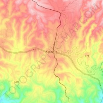
Name: Karatina topographic map, elevation, terrain.
Location: Karatina, Mathira West, Nyeri, Central Kenya, 10101, Kenya (-0.52225 37.08522 -0.44225 37.16522)
Average elevation: 5,702 ft
Minimum elevation: 5,079 ft
Maximum elevation: 6,119 ft
Thank you for supporting this site ❤️
Make a donation
Make a donation
Gear up for your next adventure:
As an Amazon Associate, this site earns from qualifying purchases at no extra cost to you.