
Pooginook topographic map
Interactive map
Click on the map to display elevation.
About this map
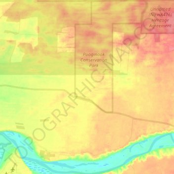
Name: Pooginook topographic map, elevation, terrain.
Average elevation: 151 ft
Minimum elevation: 20 ft
Maximum elevation: 249 ft
Other topographic maps
Click on a map to view its topography, its elevation and its terrain.
Flagstaff Hill
Australia > South Australia > The District Council of Loxton Waikerie
Flagstaff Hill, The District Council of Loxton Waikerie, South Australia, 5333, Australia
Average elevation: 89 ft
Moorook
Australia > South Australia > The District Council of Loxton Waikerie
Moorook, The District Council of Loxton Waikerie, South Australia, 5332, Australia
Average elevation: 138 ft
Paruna
Australia > South Australia > The District Council of Loxton Waikerie
Paruna, The District Council of Loxton Waikerie, South Australia, 5311, Australia
Average elevation: 184 ft
Ramco
Australia > South Australia > The District Council of Loxton Waikerie
Ramco, The District Council of Loxton Waikerie, South Australia, 5322, Australia
Average elevation: 95 ft
Waikerie
Australia > South Australia > The District Council of Loxton Waikerie
Waikerie, The District Council of Loxton Waikerie, South Australia, 5330, Australia
Average elevation: 138 ft
Woolpunda
Australia > South Australia > The District Council of Loxton Waikerie
Woolpunda, The District Council of Loxton Waikerie, South Australia, 5330, Australia
Average elevation: 213 ft
Kingston On Murray
Australia > South Australia > The District Council of Loxton Waikerie > Kingston On Murray
Kingston On Murray, The District Council of Loxton Waikerie, South Australia, 5331, Australia
Average elevation: 95 ft
Kingston on Murray
Australia > South Australia > The District Council of Loxton Waikerie
Kingston on Murray, The District Council of Loxton Waikerie, South Australia, 5331, Australia
Average elevation: 105 ft
Loxton
Australia > South Australia > The District Council of Loxton Waikerie
Loxton, The District Council of Loxton Waikerie, South Australia, 5333, Australia
Average elevation: 121 ft
Murbko
Australia > South Australia > The District Council of Loxton Waikerie
Murbko, The District Council of Loxton Waikerie, South Australia, 5320, Australia
Average elevation: 128 ft