
Mosel topographic map
Interactive map
Click on the map to display elevation.
About this map
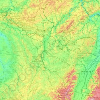
Name: Mosel topographic map, elevation, terrain.
Average elevation: 1,043 ft
Minimum elevation: 213 ft
Maximum elevation: 4,856 ft
Die Mosel entspringt in den südlichen Vogesen nahe dem Col de Bussang auf etwa 700 m Höhe und mündet in Koblenz am Deutschen Eck, dessen Nordnordostende auf 64,7 m ü. NHN liegt, auf 59,7 m Höhe von Westen in den Rhein.
Other topographic maps
Click on a map to view its topography, its elevation and its terrain.
Heissfeld
Frankreich > Großer Osten > Rüsdorf
Heissfeld, Rüsdorf, Diedenhofen, Mosel, Großer Osten, Metropolitanes Frankreich, 57480, Frankreich
Average elevation: 863 ft