
Make a donation
Gear up for your next adventure:
As an Amazon Associate, this site earns from qualifying purchases at no extra cost to you.
Renai Township topographic map
Click on the map to display elevation.
Make a donation
Gear up for your next adventure:
As an Amazon Associate, this site earns from qualifying purchases at no extra cost to you.
Renai Township
Ren'ai Township (Chinese: 仁愛鄉; pinyin: Rén'ài Xiāng; Wade–Giles: Jen2-ai4 Hsiang1) is a mountain indigenous township in Nantou County, Taiwan. It has a population total of 15,670 and an area of 1,273.5312 km2, making it the second largest township by area in the county after Xinyi Township. The populations is mainly of the indigenous Seediq, Atayal and Bunun peoples. At an average elevation of 1,669 m (5,476 ft), it is one of the highest settlements in Taiwan.
Make a donation
Gear up for your next adventure:
As an Amazon Associate, this site earns from qualifying purchases at no extra cost to you.
About this map
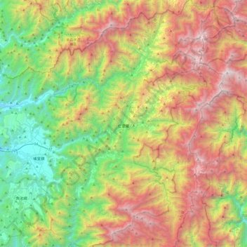
Name: Renai Township topographic map, elevation, terrain.
Location: Renai Township, Nantou County, 546, Taiwan (23.80915 120.93750 24.24588 121.34942)
Average elevation: 5,476 ft
Minimum elevation: 1,135 ft
Maximum elevation: 11,732 ft
Make a donation
Gear up for your next adventure:
As an Amazon Associate, this site earns from qualifying purchases at no extra cost to you.
Other topographic maps
Click on a map to view its topography, its elevation and its terrain.
Wuling
Taiwan > Nantou County > Renai Township
Wuling (Chinese: 武嶺; pinyin: Wǔlǐng, el 3275 m), formerly known as Sakuma Pass (佐久間峠, Sakuma-tōge), is a mountain pass located in Ren'ai, Nantou, Taiwan, transversing the Central Mountain Range near the peak of Hehuanshan within Taroko National Park. It is the highest paved road in elevation in Taiwan.
Average elevation: 10,102 ft
Qingjing Farm
Taiwan > Nantou County > Renai Township
The Qingjing Farm (traditional Chinese: 清境農場; simplified Chinese: 清境农场; pinyin: Qīngjìng Nóngchǎng), also known as Cingjing Farm, is a tourist attraction farm in Ren'ai Township, Nantou County, Taiwan. Located at an altitude of 1,700 ~2,000 meters, it's known as one of the three major high…
Average elevation: 5,052 ft
Make a donation
Gear up for your next adventure:
As an Amazon Associate, this site earns from qualifying purchases at no extra cost to you.
Qingjing Farm
Taiwan > Nantou County > Renai Township
The Qingjing Farm (traditional Chinese: 清境農場; simplified Chinese: 清境农场; pinyin: Qīngjìng Nóngchǎng), also known as Cingjing Farm, is a tourist attraction farm in Ren'ai Township, Nantou County, Taiwan. Located at an altitude of 1,700 ~2,000 meters, it's known as one of the three major high…
Average elevation: 5,052 ft