
Lungern topographic map
Interactive map
Click on the map to display elevation.
About this map
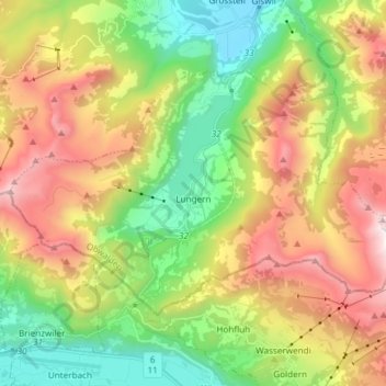
Name: Lungern topographic map, elevation, terrain.
Location: Lungern, Obwald, 6078, Suisse (46.75484 8.08988 46.81962 8.23907)
Average elevation: 4,104 ft
Minimum elevation: 1,581 ft
Maximum elevation: 7,697 ft
Other topographic maps
Click on a map to view its topography, its elevation and its terrain.
Stalden (Sarnen)
Stalden (Sarnen), Sarnen, Obwald, 6063, Suisse
Average elevation: 2,572 ft
Alpnachstad
Alpnachstad, Alpnach, Obwald, 6053, Suisse
Average elevation: 2,510 ft