
紫金山 topographic map
Interactive map
Click on the map to display elevation.
About this map
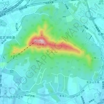
Name: 紫金山 topographic map, elevation, terrain.
Location: 紫金山, 7, 玄武区, 南京市, 江苏省, 中国 (32.03801 118.81433 32.09470 118.88321)
Average elevation: 240 ft
Minimum elevation: 30 ft
Maximum elevation: 1,421 ft
紫金山,又名蔣山、鍾山、神烈山,是一處位于中国江蘇南京城东側的山陵。其东西向長度约7公里,南北向長度约3公里,面积約20平方公里。 其主峰北高峰海拔高程約448.2米。
Other topographic maps
Click on a map to view its topography, its elevation and its terrain.