
Fischenthal topographic map
Interactive map
Click on the map to display elevation.
About this map
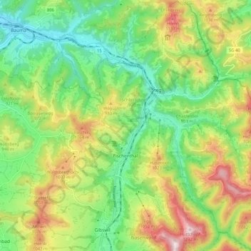
Name: Fischenthal topographic map, elevation, terrain.
Location: Fischenthal, Bezirk Hinwil, Zurich, Suisse (47.30712 8.88834 47.37592 8.98494)
Average elevation: 2,831 ft
Minimum elevation: 2,083 ft
Maximum elevation: 4,035 ft
Other topographic maps
Click on a map to view its topography, its elevation and its terrain.
Hinwil
Suisse > Zurich > Bezirk Hinwil
Hinwil, Bezirk Hinwil, Zurich, Suisse
Average elevation: 2,139 ft
Wetzikon (ZH)
Suisse > Zurich > Bezirk Hinwil
Wetzikon (ZH), Bezirk Hinwil, Zurich, Suisse
Average elevation: 1,847 ft