
Tegal topographic map
Interactive map
Click on the map to display elevation.
About this map
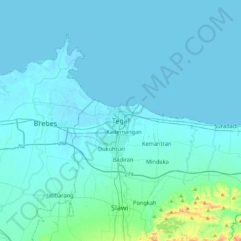
Name: Tegal topographic map, elevation, terrain.
Location: Tegal, Central Java, 52181, Indonesia (-7.02738 108.97788 -6.70738 109.29788)
Average elevation: 49 ft
Minimum elevation: -7 ft
Maximum elevation: 771 ft
Other topographic maps
Click on a map to view its topography, its elevation and its terrain.
Kademangan
Indonesia > Central Java > Tegal
Kademangan, Tegal, Central Java, Java, 52124, Indonesia
Average elevation: 23 ft