
Rutino topographic map
Interactive map
Click on the map to display elevation.
About this map
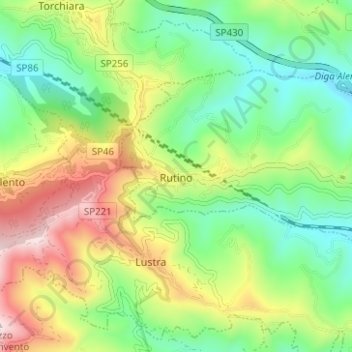
Name: Rutino topographic map, elevation, terrain.
Location: Rutino, Salerno, Kampanien, Italien (40.28554 15.06259 40.31431 15.12504)
Average elevation: 1,004 ft
Minimum elevation: 279 ft
Maximum elevation: 2,218 ft
Lustra<?> liegt auf etwa 370 Meter Höhe, nordöstlich des Monte Stella, des höchsten Bergs in der näheren Umgebung, und ist Teil des Nationalparks Cilento und Vallo di Diano, sowie der Comunità Montana Alento-Monte Stella.
Other topographic maps
Click on a map to view its topography, its elevation and its terrain.
Vietri sul Mare
Vietri sul Mare, Salerno, Kampanien, Italien
Average elevation: 479 ft
Roccadaspide
Roccadaspide, Salerno, Kampanien, 84069, Italien
Average elevation: 1,175 ft
Hangar
Italien > Kampanien > Salerno > Santa Marina
Hangar, Santa Marina, Salerno, Kampanien, 84067, Italien
Average elevation: 299 ft
Giffoni Valle Piana
Giffoni Valle Piana, Salerno, Kampanien, 84095, Italien
Average elevation: 1,831 ft
Contursi Terme
Contursi Terme, Salerno, Kampanien, 84024, Italien
Average elevation: 774 ft