Geolocate

Chiswick topographic map

Click on the map to display elevation.

About this map

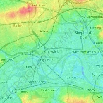
Name: Chiswick topographic map, elevation, terrain.

Location: Chiswick, Greater London, England, W4 5UL, United Kingdom (51.45231 -0.30382 51.53231 -0.22382)

Average elevation: 59 ft

Minimum elevation: -26 ft

Maximum elevation: 230 ft

Gear up for your next adventure:

🥾Men's Hiking Boots - Durable, waterproof footwear for rugged terrain and steep inclines
🪶Trail Camera - Capture wildlife on your hikes
❄️Traction Cleats - Prevent slips on icy trails during winter hikes
🌎3D Topographic Globes - Raised relief globes for a tactile understanding of geography
📶Vehicle Signal Boosters - Improve reception in rural areas while driving to trailheads

As an Amazon Associate, this site earns from qualifying purchases at no extra cost to you.