
Feldberg (Ort) topographic map
Interactive map
Click on the map to display elevation.
About this map
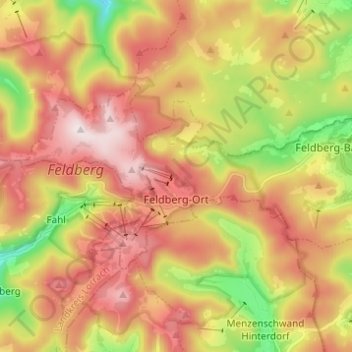
Name: Feldberg (Ort) topographic map, elevation, terrain.
Average elevation: 3,737 ft
Minimum elevation: 2,395 ft
Maximum elevation: 4,908 ft
Other topographic maps
Click on a map to view its topography, its elevation and its terrain.
Feldberg
Duitsland > Baden-Württemberg > Feldberg
Feldberg, Verwaltungsgemeinschaft Schluchsee, Landkreis Breisgau-Hochschwarzwald, Regierungsbezirk Freiburg, Baden-Württemberg, Duitsland
Average elevation: 4,236 ft