
São Julião topographic map
Interactive map
Click on the map to display elevation.
About this map
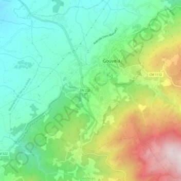
Name: São Julião topographic map, elevation, terrain.
Location: São Julião, Gouveia, Guarda, 6290-320, Portugal (40.46941 -7.62059 40.50573 -7.56937)
Average elevation: 2,310 ft
Minimum elevation: 1,555 ft
Maximum elevation: 3,734 ft
Other topographic maps
Click on a map to view its topography, its elevation and its terrain.
Nespereira
Nespereira, Gouveia, Guarda, 6290-205, Portugal
Average elevation: 1,654 ft
Folgosinho
Folgosinho, Gouveia, Guarda, 6290-081, Portugal
Average elevation: 3,107 ft