
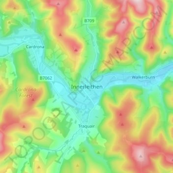
Innerleithen topographic map
Interactive map
Click on the map to display elevation.
About this map
Name: Innerleithen topographic map, elevation, terrain.
Average elevation: 958 ft
Minimum elevation: 413 ft
Maximum elevation: 1,932 ft
Other topographic maps
Click on a map to view its topography, its elevation and its terrain.
Ayton
United Kingdom > Scotland > Scottish Borders
Ayton, Scottish Borders, Scotland, TD14 5RU, United Kingdom
Average elevation: 246 ft
Peebles
United Kingdom > Scotland > Scottish Borders
Peebles, Scottish Borders, Scotland, EH45 8SL, United Kingdom
Average elevation: 902 ft
Ruddenleys
United Kingdom > Scotland > Scottish Borders
Ruddenleys, Scottish Borders, Scotland, EH46 7BN, United Kingdom
Average elevation: 1,047 ft
Stow
United Kingdom > Scotland > Scottish Borders
Stow, Scottish Borders, Scotland, TD1 2QX, United Kingdom
Average elevation: 879 ft
Galashiels
United Kingdom > Scotland > Scottish Borders
Galashiels, Scottish Borders, Scotland, United Kingdom
Average elevation: 725 ft
Earlston
United Kingdom > Scotland > Scottish Borders > Earlston
Earlston, Scottish Borders, Scotland, TD4 6BX, United Kingdom
Average elevation: 554 ft
Chirnside
United Kingdom > Scotland > Scottish Borders
Chirnside, Scottish Borders, Scotland, TD11 3UF, United Kingdom
Average elevation: 262 ft
St Leonard's
United Kingdom > Scotland > Scottish Borders > Hawick
St Leonard's, Hawick, Scottish Borders, Scotland, TD9 0PA, United Kingdom
Average elevation: 610 ft
Weird Law
United Kingdom > Scotland > Scottish Borders
Weird Law, Scottish Borders, Scotland, ML12 6QS, United Kingdom
Average elevation: 1,171 ft
Bowden
United Kingdom > Scotland > Scottish Borders > Bowden
Bowden, Scottish Borders, Scotland, TD6 0SS, United Kingdom
Average elevation: 594 ft
Eildon
United Kingdom > Scotland > Scottish Borders > Newtown St Boswells
Eildon, Newtown St Boswells, Scottish Borders, Scotland, TD6 9HH, United Kingdom
Average elevation: 449 ft
Wauchope
United Kingdom > Scotland > Scottish Borders
Wauchope, Scottish Borders, Scotland, TD9 9TG, United Kingdom
Average elevation: 784 ft