
Bestwig topographic map
Click on the map to display elevation.
About this map
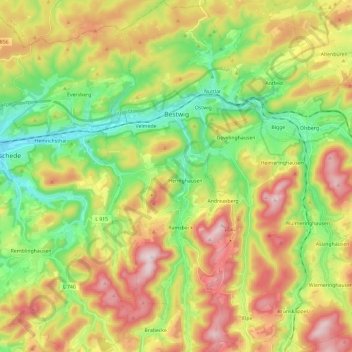
Name: Bestwig topographic map, elevation, terrain.
Average elevation: 1,529 ft
Minimum elevation: 856 ft
Maximum elevation: 2,441 ft
Other topographic maps
Click on a map to view its topography, its elevation and its terrain.
Recklinghausen (Sauerland)
Germany > North Rhine-Westphalia > Hochsauerlandkreis > Sundern
Average elevation: 1,089 ft
Berghausen
Germany > North Rhine-Westphalia > Hochsauerlandkreis > Meschede
Average elevation: 1,086 ft
Gellinghausen
Germany > North Rhine-Westphalia > Hochsauerlandkreis > Schmallenberg > Westernbödefeld
Average elevation: 1,854 ft
Grevenstein
Germany > North Rhine-Westphalia > Hochsauerlandkreis > Meschede
Average elevation: 1,368 ft
Lenneplätze
Germany > North Rhine-Westphalia > Hochsauerlandkreis > Winterberg > Neuastenberg
Average elevation: 2,293 ft
Wolkenberg
Germany > North Rhine-Westphalia > Hochsauerlandkreis > Olsberg
Average elevation: 1,739 ft
Altastenberg
Germany > North Rhine-Westphalia > Hochsauerlandkreis > Winterberg
Average elevation: 2,323 ft
Ruhrquelle
Germany > North Rhine-Westphalia > Hochsauerlandkreis > Winterberg > Grönebach
Average elevation: 2,116 ft
Niedersfeld
Germany > North Rhine-Westphalia > Hochsauerlandkreis > Winterberg
Average elevation: 2,149 ft
Neuastenberg
Germany > North Rhine-Westphalia > Hochsauerlandkreis > Winterberg
Average elevation: 2,247 ft
Wormbach
Germany > North Rhine-Westphalia > Hochsauerlandkreis > Schmallenberg
Average elevation: 1,424 ft
Hachen
Germany > North Rhine-Westphalia > Hochsauerlandkreis > Sundern > Hachen
Average elevation: 961 ft