
Make a donation
Gear up for your next adventure:
As an Amazon Associate, this site earns from qualifying purchases at no extra cost to you.
Comayagüela topographic map
Click on the map to display elevation.
Make a donation
Gear up for your next adventure:
As an Amazon Associate, this site earns from qualifying purchases at no extra cost to you.
Comayagüela
Tegucigalpa is located on a chain of mountains with elevations of 975 metres (3,199 ft) at its lowest points and 1,463 metres (4,800 ft) at its highest suburban areas. Like most of the interior highlands of Honduras, the majority of Tegucigalpa's current area was occupied by open woodland. The area surrounding the city continues to be open woodland supporting pine forest interspersed with some oak, scrub, and grassy clearings as well as needle leaf evergreen and broadleaf deciduous forest.
Make a donation
Gear up for your next adventure:
As an Amazon Associate, this site earns from qualifying purchases at no extra cost to you.
About this map
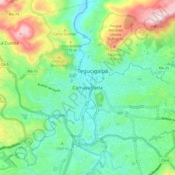
Name: Comayagüela topographic map, elevation, terrain.
Average elevation: 3,484 ft
Minimum elevation: 2,920 ft
Maximum elevation: 4,797 ft
Make a donation
Gear up for your next adventure:
As an Amazon Associate, this site earns from qualifying purchases at no extra cost to you.