
Make a donation
Gear up for your next adventure:
As an Amazon Associate, this site earns from qualifying purchases at no extra cost to you.
Roaring Spring topographic map
Click on the map to display elevation.
Make a donation
Gear up for your next adventure:
As an Amazon Associate, this site earns from qualifying purchases at no extra cost to you.
Roaring Spring
Roaring Spring was established around the Big Spring in Morrison's Cove, a clean and dependable water source vital to the operation of a paper mill. Prior to 1866, when the first paper mill was built, Roaring Spring had been a grist mill hamlet with a country store at the intersection of two rural roads that lead to the mill near the spring. A grist mill, powered by the spring water, had operated at that location since at least the 1760s. After 1867, as the paper mill expanded, surrounding tracts of land were acquired to accommodate housing development for new workers. The formalization of a town plan, however, never occurred. As a result, the seemingly random street pattern of the historic district is the product of hilly topography, a small network of pre-existing country roads that converged near the Big Spring, and the property lines of adjacent tracts that were acquired through the years for community expansion. The arterial streets of the district are now East Main, West Main, Spang and Bloomfield, each of which leads out of the borough to surrounding townships. Two of these streets — Spang and East Main — meet with Church Street at the district's main intersection called "Five Points." The boundaries of the district essentially include those portions of Roaring Spring Borough which had been laid out for development by the early 1920s. This area encompasses 233 acres (0.94 km2) or 55 percent of the borough's area of 421 acres (1.70 km2). Since the district's period of significance extends to 1944, most of those buildings erected after the 1920s were built as infill within the areas already subdivided by the 1920s. In the early 1960s, the borough began to annex sections of adjacent Taylor Township, especially to the east around the then new Rt. 36 Bypass.
Make a donation
Gear up for your next adventure:
As an Amazon Associate, this site earns from qualifying purchases at no extra cost to you.
About this map
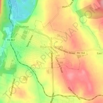
Name: Roaring Spring topographic map, elevation, terrain.
Location: Roaring Spring, Blair County, Pennsylvania, United States (40.32637 -78.40802 40.34291 -78.38101)
Average elevation: 1,299 ft
Minimum elevation: 1,089 ft
Maximum elevation: 1,450 ft
Blair County trails, hiking, mountain biking, running and outdoor activities
Make a donation
Gear up for your next adventure:
As an Amazon Associate, this site earns from qualifying purchases at no extra cost to you.
Other topographic maps
Click on a map to view its topography, its elevation and its terrain.
East Freedom
United States > Pennsylvania > Blair County > Freedom Township
Average elevation: 1,217 ft
Make a donation
Gear up for your next adventure:
As an Amazon Associate, this site earns from qualifying purchases at no extra cost to you.
Make a donation
Gear up for your next adventure:
As an Amazon Associate, this site earns from qualifying purchases at no extra cost to you.
Canoe Creek
United States > Pennsylvania > Blair County > Frankstown Township
Average elevation: 1,138 ft
Canoe Creek
United States > Pennsylvania > Blair County > Frankstown Township
Average elevation: 1,138 ft
Make a donation
Gear up for your next adventure:
As an Amazon Associate, this site earns from qualifying purchases at no extra cost to you.
Mill Run
United States > Pennsylvania > Blair County > Altoona > Allegheny Furnace
Average elevation: 1,145 ft
Make a donation
Gear up for your next adventure:
As an Amazon Associate, this site earns from qualifying purchases at no extra cost to you.
Greenwood
United States > Pennsylvania > Blair County > Logan Township > Greenwood
Average elevation: 1,398 ft