
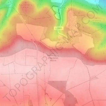
Wettenburg (Hainleite) topographic map
Interactive map
Click on the map to display elevation.
About this map
Name: Wettenburg (Hainleite) topographic map, elevation, terrain.
Average elevation: 1,362 ft
Minimum elevation: 817 ft
Maximum elevation: 1,529 ft
Other topographic maps
Click on a map to view its topography, its elevation and its terrain.
Thalebra
Deutschland > Thüringen > Kyffhäuserkreis > Sondershausen
Thalebra, Sondershausen, Kyffhäuserkreis, Thüringen, Deutschland
Average elevation: 925 ft
Großberndten
Deutschland > Thüringen > Kyffhäuserkreis > Sondershausen
Großberndten, Sondershausen, Kyffhäuserkreis, Thüringen, 99706, Deutschland
Average elevation: 1,283 ft
Großfurra
Deutschland > Thüringen > Kyffhäuserkreis > Sondershausen
Großfurra, Sondershausen, Kyffhäuserkreis, Thüringen, 99706, Deutschland
Average elevation: 906 ft