
Make a donation
Gear up for your next adventure:
As an Amazon Associate, this site earns from qualifying purchases at no extra cost to you.
Val Thorens topographic map
Click on the map to display elevation.
Make a donation
Gear up for your next adventure:
As an Amazon Associate, this site earns from qualifying purchases at no extra cost to you.
Val Thorens
Val Thorens ([val tɔʁɑ̃]) is a ski town in the Tarentaise Valley in the French Alps at an altitude of 2,300 m (7,500 ft). It is located in the commune of Saint-Martin-de-Belleville in the Savoie department. The resort forms part of the Les Trois Vallées ski area which, with over 600 km of slopes, is one of the largest linked ski areas in the world.
Make a donation
Gear up for your next adventure:
As an Amazon Associate, this site earns from qualifying purchases at no extra cost to you.
About this map
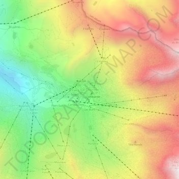
Name: Val Thorens topographic map, elevation, terrain.
Average elevation: 8,255 ft
Minimum elevation: 6,280 ft
Maximum elevation: 10,318 ft
Make a donation
Gear up for your next adventure:
As an Amazon Associate, this site earns from qualifying purchases at no extra cost to you.
Other topographic maps
Click on a map to view its topography, its elevation and its terrain.
Make a donation
Gear up for your next adventure:
As an Amazon Associate, this site earns from qualifying purchases at no extra cost to you.
Les Sybelles
France > Auvergne-Rhône-Alpes > Savoy > Fontcouverte-la-Toussuire
Average elevation: 5,682 ft
Albertville
France > Auvergne-Rhône-Alpes > Savoy
Albertville is situated on the river Arly, close to the confluence with the river Isère. Its altitude ranges from 345 to 2,037 metres (1,132 to 6,683 ft). Nearby mountains include: Belle Étoile, Dent de Cons, Négresse, Roche Pourrie, Mirantin, Pointe de la Grande Journée, Chaîne du Grand Arc. Nearby…
Average elevation: 1,952 ft
Make a donation
Gear up for your next adventure:
As an Amazon Associate, this site earns from qualifying purchases at no extra cost to you.
Lac du Mont-Cenis
France > Auvergne-Rhône-Alpes > Savoy > Val-Cenis
Mont-Cenis Lake is a lake located in the Mont-Cenis massif at an altitude of 1,974 meters (6,476 ft) in the municipality of Val-Cenis in France. It is situated at the top of the Cenise valley, on the Italian side of the Mont-Cenis pass, the most frequented passage on the Lyon-Turin-Milan axis during the Middle…
Average elevation: 6,877 ft
Make a donation
Gear up for your next adventure:
As an Amazon Associate, this site earns from qualifying purchases at no extra cost to you.
Make a donation
Gear up for your next adventure:
As an Amazon Associate, this site earns from qualifying purchases at no extra cost to you.
Bonneval-sur-Arc
France > Auvergne-Rhône-Alpes > Savoy
Bonneval-sur-Arc features an alpine climate due to its high elevation, just under the tree line. Its climate is characterised by very cold, snowy winters and cool, stormy summers.
Average elevation: 8,648 ft
Make a donation
Gear up for your next adventure:
As an Amazon Associate, this site earns from qualifying purchases at no extra cost to you.
Make a donation
Gear up for your next adventure:
As an Amazon Associate, this site earns from qualifying purchases at no extra cost to you.
Tignes
France > Auvergne-Rhône-Alpes > Savoy
The terrain of valley lends itself to more challenging skiing, with advanced skiers often opting for the resort as their preferred ski area. The town has however strived to improve its appeal to beginner and intermediate skiers with the introduction of easier runs lower down in the valley towards…
Average elevation: 8,268 ft
Make a donation
Gear up for your next adventure:
As an Amazon Associate, this site earns from qualifying purchases at no extra cost to you.
Tignes
France > Auvergne-Rhône-Alpes > Savoy
The terrain of valley lends itself to more challenging skiing, with advanced skiers often opting for the resort as their preferred ski area. The town has however strived to improve its appeal to beginner and intermediate skiers with the introduction of easier runs lower down in the valley towards…
Average elevation: 8,268 ft
Make a donation
Gear up for your next adventure:
As an Amazon Associate, this site earns from qualifying purchases at no extra cost to you.
Aix-les-Bains
France > Auvergne-Rhône-Alpes > Savoy
Aix-les-Bains is located in the southeast of France, 107 kilometres (66 mi) east of Lyon. The town is located in a corridor between the mountain of Mont Revard, the first natural rampart of the Massif des Bauges to the east and the Lac du Bourget, the largest natural lake of France to the west. Thus, the city…
Average elevation: 1,142 ft
Saint-Sorlin-d'Arves
France > Auvergne-Rhône-Alpes > Savoy
It is a ski resort, part of the larger Les Sybelles area. Gaston Maulin's project of linking St Sorlin with the La Toussuire and Le Corbier ski resorts has created Les Sybelles, an area that ranks high in the list of the largest French ski areas, with over 300 kilometres of intermediate level skiing. The St…
Average elevation: 6,555 ft
Make a donation
Gear up for your next adventure:
As an Amazon Associate, this site earns from qualifying purchases at no extra cost to you.
Aix-les-Bains
France > Auvergne-Rhône-Alpes > Savoy
Aix-les-Bains is located in the southeast of France, 107 kilometres (66 mi) east of Lyon. The town is located in a corridor between the mountain of Mont Revard, the first natural rampart of the Massif des Bauges to the east and the Lac du Bourget, the largest natural lake of France to the west. Thus, the city…
Average elevation: 1,142 ft
Make a donation
Gear up for your next adventure:
As an Amazon Associate, this site earns from qualifying purchases at no extra cost to you.
Lac du Grand Méan
France > Auvergne-Rhône-Alpes > Savoy > Bonneval-sur-Arc
Average elevation: 9,255 ft
Make a donation
Gear up for your next adventure:
As an Amazon Associate, this site earns from qualifying purchases at no extra cost to you.
Bessans
France > Auvergne-Rhône-Alpes > Savoy
Located on the Haute-Maurienne plateau, at an altitude of 1750 meters, the area is known for its sporting activities. Bessans is located in a valley, ideal for Nordic skiing. Following the collapse of the mountain downstream from Bessans (between 10000 and 3000 years BC), an ice-dammed lake formed. The…
Average elevation: 8,307 ft
Glacier de la Grande Casse
France > Auvergne-Rhône-Alpes > Savoy > Pralognan-la-Vanoise
Average elevation: 9,501 ft
Communauté de communes de Haute Tarentaise
France > Auvergne-Rhône-Alpes > Savoy
Average elevation: 7,178 ft
Make a donation
Gear up for your next adventure:
As an Amazon Associate, this site earns from qualifying purchases at no extra cost to you.
Modane
France > Auvergne-Rhône-Alpes > Savoy
In 1969, the city turned to tourism. A chairlift departing from Fourneaux and joining the hamlet of Charmaix on the commune of Modane, at 1,550 metres (5,090 ft) altitude, was indeed created, like the d'Arrondaz snow stadium, allowing skiing at 1,550 to 2,500 metres (5,090 to 8,200 ft) altitude.
Average elevation: 7,352 ft
Albertville
France > Auvergne-Rhône-Alpes > Savoy
Albertville is situated on the river Arly, close to the confluence with the river Isère. Its altitude ranges from 345 to 2,037 metres (1,132 to 6,683 ft). Nearby mountains include: Belle Étoile, Dent de Cons, Négresse, Roche Pourrie, Mirantin, Pointe de la Grande Journée, Chaîne du Grand Arc. Nearby…
Average elevation: 1,952 ft
Make a donation
Gear up for your next adventure:
As an Amazon Associate, this site earns from qualifying purchases at no extra cost to you.
73700
France > Auvergne-Rhône-Alpes > Savoy > Bourg-Saint-Maurice > Versoye-les-Granges
Average elevation: 6,558 ft
Albertville
France > Auvergne-Rhône-Alpes > Savoy
Albertville is situated on the river Arly, close to the confluence with the river Isère. Its altitude ranges from 345 to 2,037 metres (1,132 to 6,683 ft). Nearby mountains include: Belle Étoile, Dent de Cons, Négresse, Roche Pourrie, Mirantin, Pointe de la Grande Journée, Chaîne du Grand Arc. Nearby…
Average elevation: 1,952 ft
Make a donation
Gear up for your next adventure:
As an Amazon Associate, this site earns from qualifying purchases at no extra cost to you.
73210
France > Auvergne-Rhône-Alpes > Savoy > La Plagne-Tarentaise > Sangot
Average elevation: 5,794 ft
Make a donation
Gear up for your next adventure:
As an Amazon Associate, this site earns from qualifying purchases at no extra cost to you.
Saint-Jean-de-Belleville
France > Auvergne-Rhône-Alpes > Savoy > Les Belleville
Average elevation: 5,925 ft
Make a donation
Gear up for your next adventure:
As an Amazon Associate, this site earns from qualifying purchases at no extra cost to you.
Lac du Bourget
France > Auvergne-Rhône-Alpes > Savoy > Brison-Saint-Innocent
Average elevation: 1,460 ft
73700
France > Auvergne-Rhône-Alpes > Savoy > Bourg-Saint-Maurice > Versoye-les-Granges
Average elevation: 6,558 ft
Make a donation
Gear up for your next adventure:
As an Amazon Associate, this site earns from qualifying purchases at no extra cost to you.
Make a donation
Gear up for your next adventure:
As an Amazon Associate, this site earns from qualifying purchases at no extra cost to you.
Modane
France > Auvergne-Rhône-Alpes > Savoy
In 1969, the city turned to tourism. A chairlift departing from Fourneaux and joining the hamlet of Charmaix on the commune of Modane, at 1,550 metres (5,090 ft) altitude, was indeed created, like the d'Arrondaz snow stadium, allowing skiing at 1,550 to 2,500 metres (5,090 to 8,200 ft) altitude.
Average elevation: 7,352 ft
Make a donation
Gear up for your next adventure:
As an Amazon Associate, this site earns from qualifying purchases at no extra cost to you.
Saint-Sorlin-d'Arves
France > Auvergne-Rhône-Alpes > Savoy
It is a ski resort, part of the larger Les Sybelles area. Gaston Maulin's project of linking St Sorlin with the La Toussuire and Le Corbier ski resorts has created Les Sybelles, an area that ranks high in the list of the largest French ski areas, with over 300 kilometres of intermediate level skiing. The St…
Average elevation: 6,555 ft
Make a donation
Gear up for your next adventure:
As an Amazon Associate, this site earns from qualifying purchases at no extra cost to you.
Make a donation
Gear up for your next adventure:
As an Amazon Associate, this site earns from qualifying purchases at no extra cost to you.
Le Chantel
France > Auvergne-Rhône-Alpes > Savoy > Bourg-Saint-Maurice > Arc 1800
Average elevation: 5,807 ft
Make a donation
Gear up for your next adventure:
As an Amazon Associate, this site earns from qualifying purchases at no extra cost to you.
Make a donation
Gear up for your next adventure:
As an Amazon Associate, this site earns from qualifying purchases at no extra cost to you.
Modane
France > Auvergne-Rhône-Alpes > Savoy
In 1969, the city turned to tourism. A chairlift departing from Fourneaux and joining the hamlet of Charmaix on the commune of Modane, at 1,550 metres (5,090 ft) altitude, was indeed created, like the d'Arrondaz snow stadium, allowing skiing at 1,550 to 2,500 metres (5,090 to 8,200 ft) altitude.
Average elevation: 7,352 ft
Make a donation
Gear up for your next adventure:
As an Amazon Associate, this site earns from qualifying purchases at no extra cost to you.