
Bayeux topographic map
Interactive map
Click on the map to display elevation.
Bayeux
Bayeux is located 7 kilometres (4 miles) from the coast of the English Channel and 30 km (19 mi) north-west of Caen. The city, with elevations varying from 32 to 67 metres (105 to 220 feet) above sea level – with an average of 46 metres (151 feet) – is bisected by the River Aure. Bayeux is located at the crossroads of RN 13 and the train route Paris-Caen-Cherbourg. The city is the capital of the Bessin, which extends north-west of Calvados. Bayeux station has rail connections to Caen, Cherbourg, Granville and Paris.
About this map
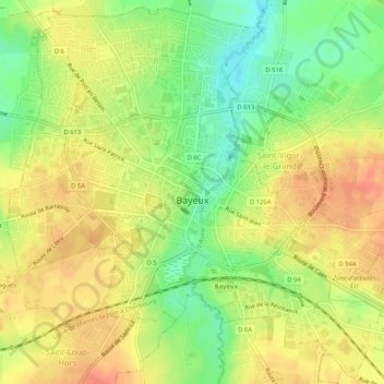
Name: Bayeux topographic map, elevation, terrain.
Location: Bayeux, Calvados, Normandy, Metropolitan France, 14400, France (49.26081 -0.72757 49.29347 -0.67574)
Average elevation: 180 ft
Minimum elevation: 98 ft
Maximum elevation: 240 ft
Other topographic maps
Click on a map to view its topography, its elevation and its terrain.
Pointe du Hoc
France > Normandy > Calvados > Cricqueville-en-Bessin > Le Pont du Hable
Average elevation: 39 ft