
Badenhausen topographic map
Interactive map
Click on the map to display elevation.
About this map
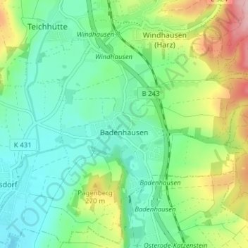
Name: Badenhausen topographic map, elevation, terrain.
Average elevation: 689 ft
Minimum elevation: 502 ft
Maximum elevation: 1,109 ft
Other topographic maps
Click on a map to view its topography, its elevation and its terrain.
Gittelde
Deutschland > Niedersachsen > Landkreis Göttingen > Bad Grund
Gittelde, Bad Grund, Landkreis Göttingen, Niedersachsen, Deutschland
Average elevation: 886 ft