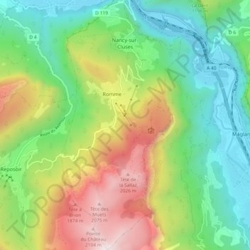
Nancy-sur-Cluses topographic map
Interactive map
Click on the map to display elevation.
About this map
Name: Nancy-sur-Cluses topographic map, elevation, terrain.
Average elevation: 3,586 ft
Minimum elevation: 1,578 ft
Maximum elevation: 7,201 ft

Click on the map to display elevation.
Name: Nancy-sur-Cluses topographic map, elevation, terrain.
Average elevation: 3,586 ft
Minimum elevation: 1,578 ft
Maximum elevation: 7,201 ft