
Val-de-Travers topographic map
Interactive map
Click on the map to display elevation.
About this map
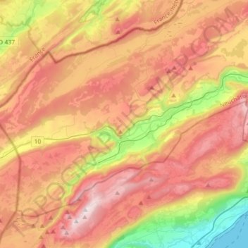
Name: Val-de-Travers topographic map, elevation, terrain.
Location: Val-de-Travers, Neuchâtel, Switzerland (46.85870 6.46957 46.97733 6.75091)
Average elevation: 3,412 ft
Minimum elevation: 1,385 ft
Maximum elevation: 5,217 ft
Other topographic maps
Click on a map to view its topography, its elevation and its terrain.
La Chaux-de-Fonds
La Chaux-de-Fonds, Neuchâtel, Switzerland
Average elevation: 3,409 ft
Marmoud
Switzerland > Neuchâtel > La Sagne
Marmoud, La Sagne, Neuchâtel, 2314, Switzerland
Average elevation: 3,825 ft
Noiraigue
Switzerland > Neuchâtel > Val-de-Travers
Noiraigue, Val-de-Travers, Neuchâtel, 2103, Switzerland
Average elevation: 3,219 ft
Lake Neuchâtel
Switzerland > Neuchâtel > District de la Broye
Lake Neuchâtel, District de la Broye, Seeland administrative region, Neuchâtel, Switzerland
Average elevation: 2,159 ft