
Prince topographic map
Interactive map
Click on the map to display elevation.
About this map
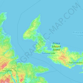
Name: Prince topographic map, elevation, terrain.
Location: Prince, Prince County, Île-du-Prince-Édouard, Canada (45.88556 -64.65785 47.28556 -63.25785)
Average elevation: 39 ft
Minimum elevation: -10 ft
Maximum elevation: 879 ft
Other topographic maps
Click on a map to view its topography, its elevation and its terrain.
St-Philippe
Canada > Île-du-Prince-Édouard > Prince County > St-Philippe
St-Philippe, Lot 14, Prince County, Île-du-Prince-Édouard, Canada
Average elevation: 98 ft