
Sungai Kenau topographic map
Interactive map
Click on the map to display elevation.
About this map
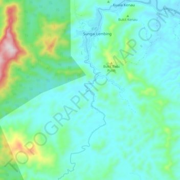
Name: Sungai Kenau topographic map, elevation, terrain.
Location: Sungai Kenau, Kuala Kenau, Kuantan, Pahang, Malaysia (3.84248 103.01527 3.93315 103.05090)
Average elevation: 463 ft
Minimum elevation: 56 ft
Maximum elevation: 2,172 ft
Other topographic maps
Click on a map to view its topography, its elevation and its terrain.
Bukit panorama
Malaysia > Pahang > Kuala Kenau
Bukit panorama, Bukit Panorama Stairs, Kuala Kenau, Kuantan, Pahang, 26200, Malaysia
Average elevation: 367 ft
Kuala Kenau
Malaysia > Pahang > Kuala Kenau
Kuala Kenau, Kuantan, Pahang, 26200, Malaysia
Average elevation: 236 ft