
Make a donation
Gear up for your next adventure:
As an Amazon Associate, this site earns from qualifying purchases at no extra cost to you.
Rajpura topographic map
Click on the map to display elevation.
Make a donation
Gear up for your next adventure:
As an Amazon Associate, this site earns from qualifying purchases at no extra cost to you.
Rajpura
Rajpura is located at 30°29′N 76°36′E / 30.48°N 76.6°E / 30.48; 76.6. It has an average elevation of 259 metres (849 feet). Rajpura is situated nearly 38 km south west of Chandigarh, the capital city of Punjab. Besides being an important industrial town of Punjab, it also has historical importance.
Make a donation
Gear up for your next adventure:
As an Amazon Associate, this site earns from qualifying purchases at no extra cost to you.
About this map
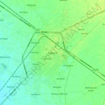
Name: Rajpura topographic map, elevation, terrain.
Location: Rajpura, Rajpura Tahsil, Patiala, Punjab, 140401, India (30.43769 76.55377 30.51769 76.63377)
Average elevation: 886 ft
Minimum elevation: 863 ft
Maximum elevation: 909 ft
Make a donation
Gear up for your next adventure:
As an Amazon Associate, this site earns from qualifying purchases at no extra cost to you.