
Bouaiche topographic map
Interactive map
Click on the map to display elevation.
About this map
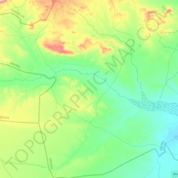
Name: Bouaiche topographic map, elevation, terrain.
Location: Bouaiche, Daïra Chahbounia, Médéa, Algérie (35.46162 2.13894 35.75961 2.49312)
Average elevation: 2,556 ft
Minimum elevation: 2,175 ft
Maximum elevation: 3,619 ft
Other topographic maps
Click on a map to view its topography, its elevation and its terrain.
Boughezoul
Algérie > Médéa > Daïra Chahbounia
Boughezoul, Daïra Chahbounia, Médéa, Algérie
Average elevation: 2,208 ft