
Neidenfels topographic map
Interactive map
Click on the map to display elevation.
About this map
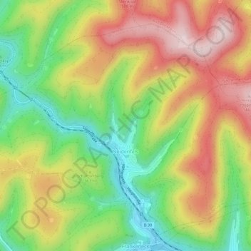
Name: Neidenfels topographic map, elevation, terrain.
Average elevation: 1,161 ft
Minimum elevation: 558 ft
Maximum elevation: 1,814 ft
Other topographic maps
Click on a map to view its topography, its elevation and its terrain.
Keltenquelle
Deutschland > Rheinland-Pfalz > Landkreis Bad Dürkheim > Bad Dürkheim
Keltenquelle, Bürgermeister-Doktor-Dahlem-Straße, Rudolf Bart-Siedlung, Grethen, Bad Dürkheim, Landkreis Bad Dürkheim, Rheinland-Pfalz, 67098, Deutschland
Average elevation: 879 ft
Weißlich
Deutschland > Rheinland-Pfalz > Landkreis Bad Dürkheim > Ruppertsberg
Weißlich, Ruppertsberg, Deidesheim, Landkreis Bad Dürkheim, Rheinland-Pfalz, 67152, Deutschland
Average elevation: 413 ft
Bad Dürkheim
Deutschland > Rheinland-Pfalz > Landkreis Bad Dürkheim
Bad Dürkheim, Landkreis Bad Dürkheim, Rheinland-Pfalz, 67098, Deutschland
Average elevation: 709 ft