
La Guienette topographic map
Interactive map
Click on the map to display elevation.
About this map
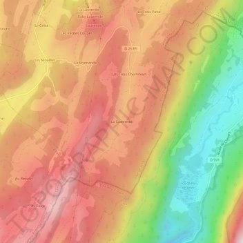
Name: La Guienette topographic map, elevation, terrain.
Average elevation: 3,855 ft
Minimum elevation: 2,671 ft
Maximum elevation: 4,721 ft
Other topographic maps
Click on a map to view its topography, its elevation and its terrain.
Les Mouilles
France > Bourgogne-Franche-Comté > Jura > Bellecombe
Les Mouilles, Bellecombe, Saint-Claude, Jura, Bourgogne-Franche-Comté, France métropolitaine, 39310, France
Average elevation: 4,009 ft
Les Trois Cheminées
France > Bourgogne-Franche-Comté > Jura > Bellecombe
Les Trois Cheminées, Bellecombe, Saint-Claude, Jura, Bourgogne-Franche-Comté, France métropolitaine, 39310, France
Average elevation: 3,862 ft