
Make a donation
Gear up for your next adventure:
As an Amazon Associate, this site earns from qualifying purchases at no extra cost to you.
Creuse topographic map
Click on the map to display elevation.
Make a donation
Gear up for your next adventure:
As an Amazon Associate, this site earns from qualifying purchases at no extra cost to you.
Creuse
It is in the Massif Central and permeated by the Creuse and its tributaries. The river is dammed at several locations both for water supply and hydroelectricity generation. As is typical for an inland area of continental Europe, Creuse has relatively cold winters with some snowfall into April, but also hot summers. Rain falls throughout the year because of the relatively high elevation.
Make a donation
Gear up for your next adventure:
As an Amazon Associate, this site earns from qualifying purchases at no extra cost to you.
About this map
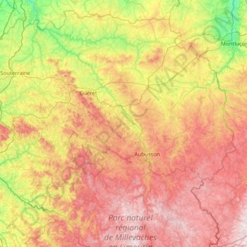
Name: Creuse topographic map, elevation, terrain.
Location: Creuse, New Aquitaine, Metropolitan France, France (45.66337 1.37254 46.45534 2.61150)
Average elevation: 1,650 ft
Minimum elevation: 495 ft
Maximum elevation: 3,205 ft
Make a donation
Gear up for your next adventure:
As an Amazon Associate, this site earns from qualifying purchases at no extra cost to you.