Geolocate

Ivochote topographic map

Click on the map to display elevation.

About this map

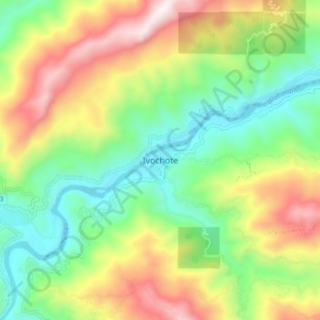
Name: Ivochote topographic map, elevation, terrain.

Location: Ivochote, Echarate, Province of La Convención, Cusco, Peru (-12.50314 -73.00458 -12.42314 -72.92458)

Average elevation: 2,871 ft

Minimum elevation: 1,575 ft

Maximum elevation: 4,879 ft

Gear up for your next adventure:

🗺️NatGeo Topo Maps - High-quality waterproof printed topographic maps of US Parks
🔦Powerful Headlamps - Ultra-bright hands-free lighting for night navigation
⛑️Personal Locator Beacon - Safety beacon for emergencies
🧤Tactile Hiking Gloves - Keep hands warm while operating GPS and smartphone screens
📱Solar Portable Charger - Solar power bank for charging devices off‑grid

As an Amazon Associate, this site earns from qualifying purchases at no extra cost to you.