
Barnstaple topographic map
Click on the map to display elevation.
About this map
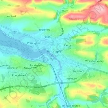
Name: Barnstaple topographic map, elevation, terrain.
Location: Barnstaple, North Devon, Devon, England, United Kingdom (51.06340 -4.08995 51.09456 -4.00251)
Average elevation: 154 ft
Minimum elevation: -7 ft
Maximum elevation: 538 ft
Other topographic maps
Click on a map to view its topography, its elevation and its terrain.
St John's Chapel
United Kingdom > England > Devon > North Devon > Eastacombe
Average elevation: 256 ft