
Pian del Re topographic map
Interactive map
Click on the map to display elevation.
About this map
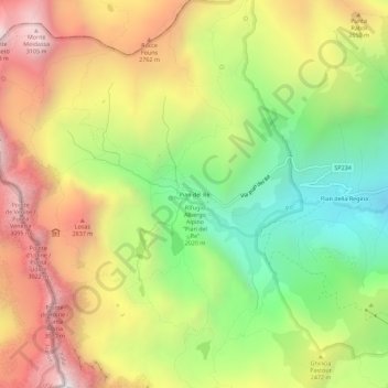
Name: Pian del Re topographic map, elevation, terrain.
Location: Pian del Re, Crissolo, Coni, Piémont, Italie (44.68066 7.07601 44.72066 7.11601)
Average elevation: 7,808 ft
Minimum elevation: 5,397 ft
Maximum elevation: 10,440 ft
Pian del Re est une localité de la haute vallée du Pô située à 2 020 m d'altitude. C'est en ce lieu que le Pô prend sa source. Pian del Re signifie en français la plaine du roi. Ce nom proviendrait de l'implantation de camps de l'armée française lors de l'invasion du duché de Savoie par François Ier.
Other topographic maps
Click on a map to view its topography, its elevation and its terrain.
Pian della Regina
Italie > Piémont > Coni > Crissolo
Pian della Regina, Crissolo, Coni, Piémont, Italie
Average elevation: 6,906 ft
Serre Uberto
Italie > Piémont > Coni > Crissolo
Serre Uberto, Crissolo, Coni, Piémont, Italie
Average elevation: 5,968 ft