
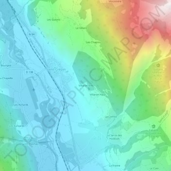
Villaron Bas topographic map
Interactive map
Click on the map to display elevation.
About this map
Name: Villaron Bas topographic map, elevation, terrain.
Average elevation: 3,953 ft
Minimum elevation: 2,910 ft
Maximum elevation: 7,382 ft
Other topographic maps
Click on a map to view its topography, its elevation and its terrain.
Les Chapins
France > Provence-Alpes-Côte d'Azur > Hautes-Alpes > Saint-Crépin
Les Chapins, Saint-Crépin, Briançon, Hautes-Alpes, Provence-Alpes-Côte d'Azur, France métropolitaine, 05600, France
Average elevation: 4,593 ft
Les Guions
France > Provence-Alpes-Côte d'Azur > Hautes-Alpes > Saint-Crépin
Les Guions, Saint-Crépin, Briançon, Hautes-Alpes, Provence-Alpes-Côte d'Azur, France métropolitaine, 05600, France
Average elevation: 4,160 ft
Le Villard
France > Provence-Alpes-Côte d'Azur > Hautes-Alpes > Saint-Crépin
Le Villard, Saint-Crépin, Briançon, Hautes-Alpes, Provence-Alpes-Côte d'Azur, France métropolitaine, 05600, France
Average elevation: 4,521 ft